
Image courtesy: Linda Sijpkes
Author: Linda Beaumont, 24 Sept 2021
While most people will visit a museum at some point, fewer are likely to enter a herbarium. Yet, both types of institutions offer far more than simply displaying and storing specimens from near and far. They are treasure troves of scientific data: the specimens they house can be used for countless biological studies. Increasingly, information associated with these specimens – their taxonomy, where and when they were collected, and more – is being digitized and made accessible to scientists and citizens alike via online databases. These data are foundational to Which Plant Where, enabling us to calculate, and map, species climatic niches and estimate how climatically suited a species is to a given region.
What is a species’ climate niche?
Simply put, a climate niche is the range of climatic conditions that populations of a species occur in. The most straight-forward way to estimate a climate niche is to use occurrence records in online databases. Let’s take the New South Wales Waratah (Telopea speciosissima), native to the Central Coast and Sydney Basin, as an example. The Atlas of Living Australia (ALA) and the Global Biodiversity Information Facility (GBIF), which collectively collate almost 2 billion specimen and observation records, contain well in excess of 1000 occurrence records for the Waratah that each have a latitude and longitude. This coordinate information can be digitally overlaid with grids of climatic variables – maximum temperature of the warmest month, precipitation of the driest month, and so on. We can then extract the climate data for each of these locations and this gives us the climate envelope, or niche, that the species occupies (Figure 1).
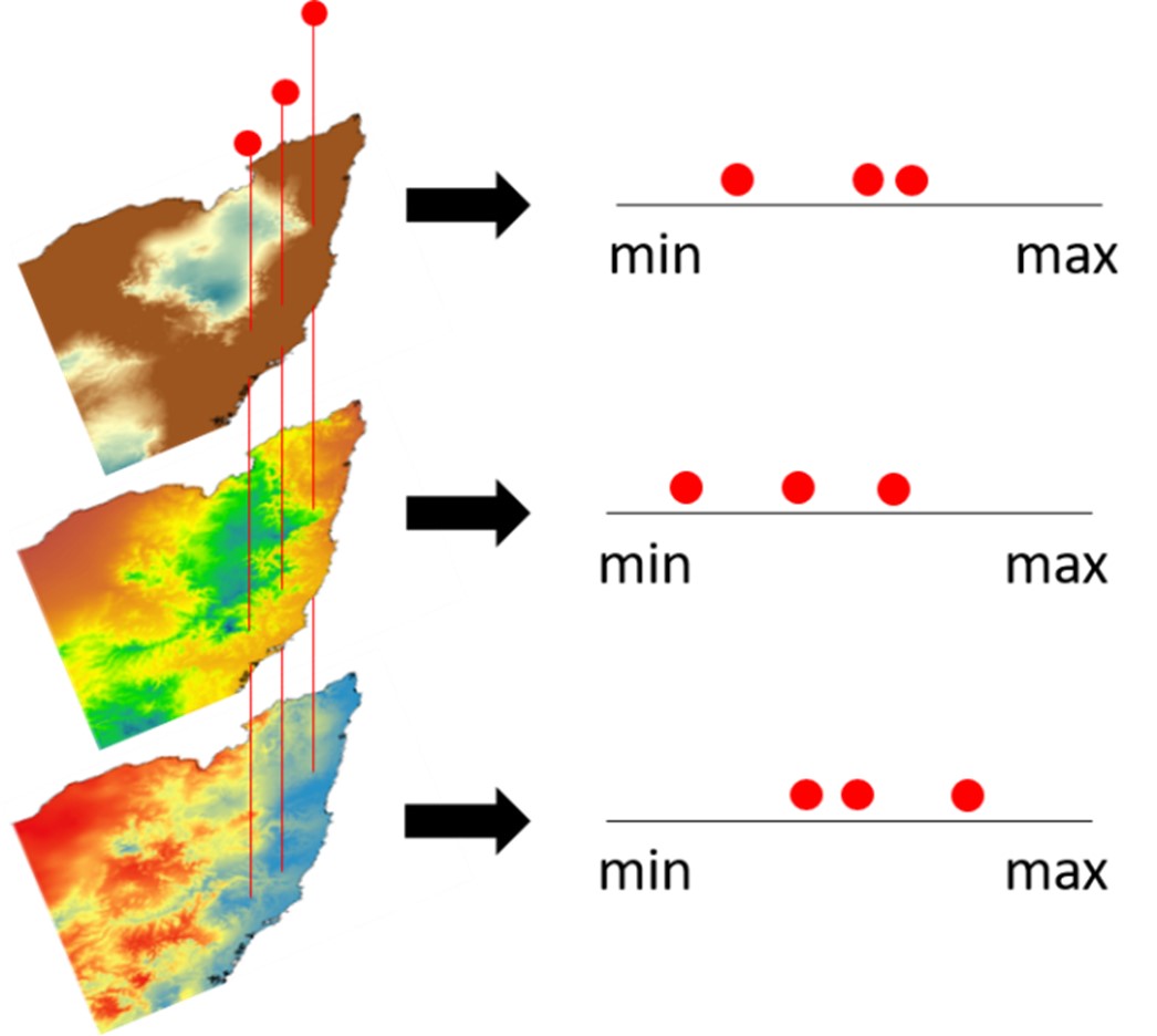
Figure 1. Representation of how a species’ climate niche can be calculated. Occurrence records with coordinate information can be overlaid onto digital maps of climate (or environmental) variables (e.g. mean annual temperature, mean annual precipitation, etc.). The value of each variable for each location can be extracted enabling the species climate niche to be estimated.
How did WPW estimate whether a species is climatically suited to a location?
We used two climate matching approaches to answer this question, depending upon the number of unique occurrence records available for a given species. Briefly, we used a simple approach for species with less than 30 records: for these, we calculated their climate niches. Then, we overlaid digital maps of postcodes and climate data so that we could quantify the climate niche of the postcode in a similar way as we did for each species. Finally, we assessed the match between the climate niches of both the postcode and the species.
For species with more than 30 unique occurrence records in ALA or GBIF, we developed more complicated statistical models of the relationship between where a species occurs and the climate of that region. These models were then used to develop maps of the climatic suitability of Australia for the species. Lastly, we summarized the results of both approaches, categorizing each postcode as unsuitable, marginal or suitable for each species. For more detail, please see our Technical Paper.
How did WPW determine whether a plant is climate-ready?
Climate-readiness refers to whether plants are likely to withstand climates of the future. Estimating this requires that we use projections of future climatologies derived from Global Climate Models (GCM). GCMs can be thought of as an extension of weather models, but whereas weather is to do with short-term patterns, climate refers to multi-decadal trends. Given the complexity of the earth’s systems, no model will ever be perfect and different models may vary in the climatology they simulate. This makes predicting future conditions rather difficult, but we can account for some of the uncertainty by using climatologies from a number of GCMs.
To determine if a species is climate-ready for a postcode, we used ten climatologies that approximate conditions for 2030, 2050 and 2070. Then, for our first climate matching approach (based on species’ niches), we once again calculated the climate niche for each postcode under each climatology, and compared it to the species’ niche. For the more complex models, we projected the species’ model onto each climatology to develop maps displaying climate suitability across Australia. Finally, we summarized results over the 10 climatologies for each time period and calculated the median suitability of each postcode: depending upon this value, the postcode was then classified as unsuitable, marginal or suitable for that species.
What are the limitations of the WPW approach?
Using occurrence records is the only approach scientists have to estimate the climate niches of a large number of species. Other available approaches are so data intensive that they can only be applied to a limited number of species. But climate matching relies on the assumption that the native range of a species is a useful measure of the breadth of climatic conditions the species can tolerate, and this is not always true (Booth, 2017; Kendal et al. 2018). Further, climate matching relies on occurrence records existing from across the species’ range – which does not always happen, particularly in under-surveyed regions that are remote or difficult to get to, such as parts of the tropics. Therefore, it is possible that some species can survive and even thrive in postcodes we have classified as marginal or unsuitable. In addition, our approach required that we summarise data at the postcode level – but some postcodes are rather large. There may well be regions of the postcode that are more (or less) suitable for some plants than other regions. Furthermore, the urban landscape contains a broad range of micro-climates that we have not been able to consider in our analysis. Thus, a plant might survive in an unsuitable postcode if micro-climatic conditions are appropriate. Similarly, providing a plant with supplemental water may enable it to survive in a postcode that would otherwise be too dry. On the other hand, a particularly warm micro-climate (e.g. against a western wall of a dark building) in an otherwise suitable postcode may prove too hot for a plant. Our analyses are also focused on species’ responses to climate and not weather. As climate changes, extreme weather events are also altering in frequency and intensity (Commonwealth of Australia, 2020). Extra care may be required during heatwaves and drought – even for plants in suitable postcodes. Finally, this approach does not consider other important factors that influence a species’ ability to survive and thrive in a particular location, such as soil type or the presence of pests and pathogens.
Ultimately, users can help to refine and expand our climate matching database by engaging in citizen science projects that expand our record of occurrences of plant species.
REFERENCES
Booth TH, 2017. Assessing species climatic requirements beyond the realized niche: some lessons mainly from tree species distribution modelling. Climatic Change 145(3):259-271. https://doi.org/10.1007/s10584-017-2107-9
Commonwealth of Australia, 2020. State of the Climate. Bureau of Meteorology and CSIRO. https://www.csiro.au/en/research/environmental-impacts/climate-change/state-of-the-climate
Kendal D, Dobbs C, Gallagher RV et al, 2018. A global comparison of the climatic niches of urban and native tree populations. Global Ecology and Biogeography 27(5):629-637. https://doi.org/10.1111/geb.12728