
Image courtesy: NOAA via Wikimedia Commons
Authors: Alessandro Ossola and Michelle Leishman, 23 Sept 2021
Urbanisation can change pretty much all physical characteristics of a landscape. Buildings, infrastructure and their materials can affect how the sun’s radiation is absorbed, reflected, stored and ultimately re-emitted towards the sky. A city can change how heat is transferred among the atmosphere, the soil and the built environment, greatly affecting land surface and air temperatures alike.
While the Urban Heat Island (UHI) effect – the increased heat affecting an urban area compared to the nearby rural landscape – has become a simple term in the everyday dictionary for many citizens, the dynamics of this event are much more complex. Urban heat can significantly change in space and time – and vary by location, seasons, and years – an invisible and variable ‘thermal archipelago’ that can greatly impact how both people and plants live in cities.
Urban heat
A number of complex factors determine how heat is transferred within urban areas and how the heat balance can tilt towards the generation of a greater or smaller urban heat island effect:
- Radiation. The incoming radiation from the sun depends on several macroclimatic and environmental factors, such as climate zone, latitude, elevation, distance from the coast, cloudiness, atmospheric dryness, air pollution and others. The greater the incoming radiation, the greater the potential for cities to ‘warm up’ and develop significant urban heat islands. However, some urban objects, such as trees, other vegetation and light-coloured surfaces, are better at reflecting some of this radiation back to the sky compared to dark-coloured objects and water bodies.
- Convection, conduction and heat transfer. When radiation is absorbed (by all urban objects), this can be remitted through numerous mechanisms. Heat can be transferred in fluids like the air via convection, much like water circulates in a boiling pot of water. When heat is transferred between physical objects touching each other, scientists call it conduction.
- Heat storage and re-radiation. Once urban objects warm up, they can re-emit thermal and other radiation into the surrounding environment. This is one of the main mechanisms behind the urban heat island effect, whereby many urban surfaces can accumulate large loads of heat during the day, to then re-emit radiation towards the sky at night, causing an increased near-surface air temperature compared to rural areas.
- Anthropogenic heat. We do all love air-conditioning during summer. Our cooling pleasures, however, add to the urban production of heat. Most cooling systems are simple pumps that funnel heat out of a home into the surrounding urban landscape. Because Australia has more than 14,400,000 air conditioning units installed (Cold Hard Facts, 2018), this army of refrigerating warriors can emit great quantities of extra heat into our cities, exacerbating the heat coming from the sun.
- Evaporation and transpiration. Have you even seen a cloud of water vapour rising from a road after summer rain during a hot day? That’s evaporation at its best. When water changes status, (from liquid to vapour in this case), it does so by “consuming” thermal energy and therefore reducing the amount of heat within the urban landscape. Transpiration is the process in which plant roots absorb water and then release the water in the form of vapour through the leaves. This not only moves water and nutrients to where it is needed within the plant, it also acts as a cooling mechanism. Just as you sweat during summer to help yourself stay cool, trees and vegetation use transpiration to maintain their internal temperatures below a critical limit that can cause permanent or lethal damage to their cells (for more info read our blog “Not all urban green is equally ‘cool’!”).
While all these factors are relatively well-understood in urban climatology, scientists are only starting to scratch the surface on how these factors will be affected by current and predicted climate change for urban locations. While temperature rise is a common factor which will impact most cities and towns in the future, the concurrent effects on precipitation and relative humidity are less well understood. It might take a few more years of research to understand whether climate change will cause drier or wetter urban heat islands in the future.
Hot islands and archipelagos
The old adage narrates that ‘the devil is in the detail’. This could not be any truer than for urban heat. In fact, the microclimate of both small and large urban areas can greatly vary within a few metres, depending on the landscape composition and structure. Even the presence of a few relatively small trees can dramatically decrease daytime land surface temperature (see figure) because tree leaves can 1) absorb solar radiation for photosynthesis, 2) dissipate energy thanks to evapotranspiration and 3) shade surfaces that can accumulate significant amounts of heat (i.e., reduce thermal load).
On the other hand, other surfaces such as building rooftops – particularly if painted in dark colours (i.e., have low albedo) and made from heat-absorbing materials – can exceed surface temperatures of 60-70°C during hot summer days (Fig. 1). In turn, by slowly releasing heat (particularly at night), these materials can significantly increase the near surface air temperature causing challenging conditions for people and plants alike.
While extreme thermal archipelagos might dissipate in a few days and hours, the acute thermal stress they impose on people and plants can be enough to push them past their maximum thermal tolerance. Unfortunately, as our plants and trees cannot move like us, this may be lethal for them if the right ‘heat tolerant’ species is not selected for a particular hot location and microclimate.
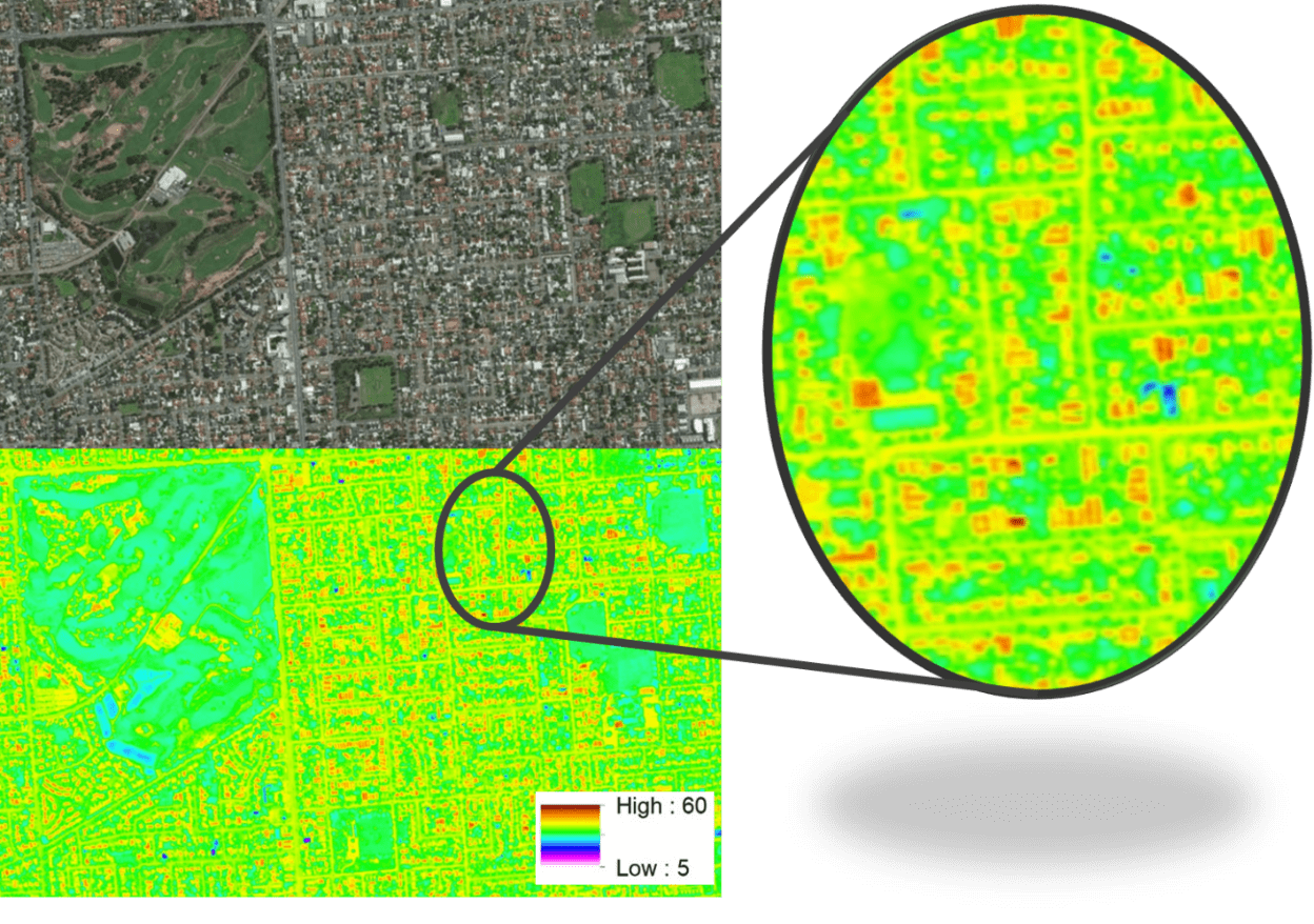
Figure 1: At fine spatial scale, urban heat is often distributed to form hotter ‘archipelagos’ across the urban landscape. The thermal map measures daytime (noon) land surface temperature in degrees Celsius during a heatwave in Adelaide, Australia in summer 2017 (Ossola et al., 2020, 2021). Building rooftops are clearly hotter than surrounding trees and vegetation. Image courtesy: AdaptWest Adelaide and Airborne Research Australia.
REFERENCES
Kershaw, T., 2017. Climate Change Resilience in the Urban Environment. IOP Publishing Ltd. Online ISBN: 978-0-7503-1197-7.
Ossola, A., Staas, L., Leishman, M, 2020. Urban trees and people’s yards mitigate extreme heat in western Adelaide: final summary report. https://doi.org/10.25949/5df2ef1637124.
Ossola, A., Jenerette, D., McGrawth, A., Chow, W., Hughes, L., Leishman, M.L., 2021. Small vegetated patches greatly reduce urban surface temperature during a summer heatwave in Adelaide, Australia. Landscape and Urban Planning, 209, 104046. https://doi.org/10.1016/j.landurbplan.2021.104046.